By Jim Kossin, Tim Hall, Mike Mann, and Stefan Rahmstorf
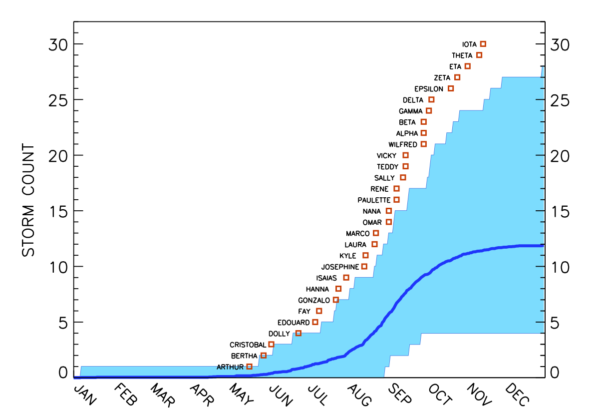
The 2020 Atlantic hurricane season broke a number of records, with the formation of an unprecedented 30 “named storms” (storms that reach wind-speed intensity of at least 18 m/s and are then given an official name). The season also started earlier than normal. In fact, when ranked by their order in the season, the date of formation of every named storm, from Tropical Storm Arthur to Hurricane Iota was substantially earlier than normal (Fig. 1).
Hurricanes
2020 vision
No-one needs another litany of all the terrible things that happened this year, but there are three areas relevant to climate science that are worth thinking about:
- What actually happened in climate/weather (and how they can be teased apart). There is a good summary on the BBC radio Discover program covering wildfires, heat waves, Arctic sea ice, the hurricane season, etc. featuring Mike Mann, Nerlie Abram, Sarah Perkins-Kilpatrick, Steve Vavrus and others. In particular, there were also some new analyses of hurricanes (their rapid intensification, slowing, greater precipitation levels etc.), as well as the expanding season for tropical storms that may have climate change components. Yale Climate Connections also has a good summary.
- The accumulation of CMIP6 results. We discussed some aspects of these results extensively – notably the increased spread in Equilibrium Climate Sensitivity, but there is a lot more work to be done on analyzing the still-growing database that will dominate the discussion of climate projections for the next few years. Of particular note will be the need for more sophisticated analyses of these model simulations that take into account observational constraints on ECS and a wider range of future scenarios (beyond just the SSP marker scenarios that were used in CMIP). These issues will be key for the upcoming IPCC 6th Assessment Report and the next National Climate Assessment.
- The intersection of climate and Covid-19.
- The direct connections are clear – massive changes in emissions of aerosols, short-lived polluting gases (like NOx) and CO2 – mainly from reductions in transportation. Initial results demonstrated a clear connection between cleaner air and the pandemic-related restrictions and behavioural changes, but so far the impacts on temperature or other climate variables appear to be too small to detect (Freidlingstein et al, 2020). The impact on global CO2 emissions (LeQuere et al, 2020) has been large (about 10% globally) – but not enough to stop CO2 concentrations from continuing to rise (that would need a reduction of more like 70-80%). Since the impact from CO2 is cumulative this won’t make a big difference in future temperatures unless it is sustained through post-pandemic changes.
- The metaphorical connections are also clear. The instant rise of corona virus-denialism, the propagation of fringe viewpoints from once notable scientists, petitions to undermine mainstream epidemiology, politicized science communications, and the difficulty in matching policy to science (even for politicians who want to just ‘follow the science’), all seem instantly recognizable from a climate change perspective. The notion that climate change was a uniquely wicked problem (because of it’s long term and global nature) has evaporated as quickly as John Ioannidis’ credibility.
I need to take time to note that there has been human toll of Covid-19 on climate science, ranging from the famous (John Houghton) to the families of people you never hear about in the press but whose work underpins the data collection, analysis and understanding we all rely on. This was/is a singular tragedy.
With the La Niña now peaking in the tropical Pacific, we can expect a slightly cooler year in 2021 and perhaps a different character of weather events, though the long-term trends will persist. My hope is that the cracks in the system that 2020 has revealed (across a swathe of issues) can serve as an motivation to improve resilience, equity and planning, across the board. That might well be the most important climate impact of all.
A happier new year to you all.
References
- P.M. Forster, H.I. Forster, M.J. Evans, M.J. Gidden, C.D. Jones, C.A. Keller, R.D. Lamboll, C.L. Quéré, J. Rogelj, D. Rosen, C. Schleussner, T.B. Richardson, C.J. Smith, and S.T. Turnock, "Current and future global climate impacts resulting from COVID-19", Nature Climate Change, vol. 10, pp. 913-919, 2020. http://dx.doi.org/10.1038/s41558-020-0883-0
- C. Le Quéré, R.B. Jackson, M.W. Jones, A.J.P. Smith, S. Abernethy, R.M. Andrew, A.J. De-Gol, D.R. Willis, Y. Shan, J.G. Canadell, P. Friedlingstein, F. Creutzig, and G.P. Peters, "Temporary reduction in daily global CO2 emissions during the COVID-19 forced confinement", Nature Climate Change, vol. 10, pp. 647-653, 2020. http://dx.doi.org/10.1038/s41558-020-0797-x
Absence and Evidence
Guest commentary by Michael Tobis, a retired climate scientist. He is a software developer and science writer living in Ottawa, Ontario.
A recent opinion piece by economist Ross McKitrick in the Financial Post, which attracted considerable attention in Canada, carried the provocative headline “This scientist proved climate change isn’t causing extreme weather – so politicians attacked”.
In fact, the scientist referenced in the headline, Roger Pielke Jr., proved no such thing. He examined some data, but he did not find compelling evidence regarding whether or not human influence is causing or influencing extreme events.
Should such a commonplace failure be broadly promoted as a decisive result that merits public interest?
[Read more…] about Absence and EvidenceDoes a slow AMOC increase the rate of global warming?
Established understanding of the AMOC (sometimes popularly called Gulf Stream System) says that a weaker AMOC leads to a slightly cooler global mean surface temperature due to changes in ocean heat storage. But now, a new paper in Nature claims the opposite and even predicts a phase of rapid global warming. What’s the story?
By Stefan Rahmstorf and Michael Mann
In 1751, the captain of an English slave-trading ship made a historic discovery. While sailing at latitude 25°N in the subtropical North Atlantic Ocean, Captain Henry Ellis lowered a “bucket sea-gauge” down through the warm surface waters into the deep. By means of a long rope and a system of valves, water from various depths could be brought up to the deck, where its temperature was read from a built-in thermometer. To his surprise Captain Ellis found that the deep water was icy cold.
These were the first ever recorded temperature measurements of the deep ocean. And they revealed what is now known to be a fundamental feature of all the world oceans: deep water is always cold. The warm waters of the tropics and subtropics are confined to a thin layer at the surface; the heat of the sun does not slowly warm up the depths as might be expected. Ellis wrote:
“This experiment, which seem’d at first but mere food for curiosity, became in the interim very useful to us. By its means we supplied our cold bath, and cooled our wines or water at pleasure; which is vastly agreeable to us in this burning climate.”
[Read more…] about Does a slow AMOC increase the rate of global warming?
Does global warming make tropical cyclones stronger?
By Stefan Rahmstorf, Kerry Emanuel, Mike Mann and Jim Kossin
Friday marks the official start of the Atlantic hurricane season, which will be watched with interest after last year’s season broke a number of records and e.g. devastated Puerto Rico’s power grid, causing serious problems that persist today. One of us (Mike) is part of a team that has issued a seasonal forecast (see Kozar et al 2012) calling for a roughly average season in terms of overall activity (10 +/- 3 named storms), with tropical Atlantic warmth constituting a favorable factor, but predicted El Nino conditions an unfavorable factor. Meanwhile, the first named storm, Alberto, has gone ahead without waiting for the official start of the season.
In the long term, whether we will see fewer or more tropical cyclones in the Atlantic or in other basins as a consequence of anthropogenic climate change is still much-debated. There is a mounting consensus, however, that we will see more intense hurricanes. So let us revisit the question of whether global warming is leading to more intense tropical storms. Let’s take a step back and look at this issue globally, not just for the Atlantic. [Read more…] about Does global warming make tropical cyclones stronger?
Why extremes are expected to change with a global warming
Joanna Walters links extreme weather events with climate change in a recent article in the Guardian, however, some reservations have been expressed about such links in past discussions.
For example, we discussed the connection between single storms and global warming in the post Hurricanes and Global Warming – Is there a connection?, the World Meteorological Organization (WMO) has issued a statement, and Mike has recently explained the connection in the Guardian.
[Read more…] about Why extremes are expected to change with a global warming
Severe Tropical Cyclone Pam and Climate Change
Guest post by Kerry Emanuel
In the past 16 months, two exceptionally intense tropical cyclones, Haiyan and Pam, have struck the western Pacific with devastating effect. Haiyan may have had the highest wind speeds of any tropical cyclone on record, but we will never know for sure because we do a poor job estimating the intensity of storms that are not surveyed by aircraft. (Currently, only North Atlantic tropical cyclones are routinely reconnoitered by aircraft, and only if they threaten populated regions within a few days.) Pam’s analyzed intensity puts it within 10 knots of the most intense storms on record in the South Pacific, but here again this is within the error bars of satellite-derived intensity estimates.
[Read more…] about Severe Tropical Cyclone Pam and Climate Change
Storm surge: Hurricane Sandy
On the second anniversary of Superstorm Sandy making landfall, we are running an extract from a new book by Adam Sobel “Storm Surge: Hurricane Sandy, Our Changing Climate, and Extreme Weather of the Past and Future”. It’s a great read covering the meteorology of the event, the preparation, the response and the implications for the future.
Improving the Tropical Cyclone Climate Record
Guest Commentary by Christopher Hennon (UNC Asheville)
Get involved in a new citizen science project at CycloneCenter.org.
The poor quality of the tropical cyclone (TC) data record provides severe constraints on the ability of climate scientists to: a) determine to what degree TCs have responded to shifts in climate, b) evaluate theories on how TCs will respond to climate change in the future. The root cause for the poor data is the severity of the TC conditions (e.g. high wind, rough seas) and the remoteness of these storms – the vast majority of which form and remain well away from most observing networks. Thus, most TCs are not observed directly and those that are (with buoys, aircraft reconnaissance, ships) are often not sampled sufficiently (see the IBTrACS, (Knapp et al., 2010)).
This leaves tropical cyclone forecasters, who are ultimately responsible for recording TC tracks and intensities (i.e. maximum wind speeds), with a challenging problem. Fortunately, there is a tool called the Dvorak Technique which allows forecasters to make a reasonable determination of the TC intensity by simply analyzing a single infrared or visible satellite image, which is almost always available Velden et al., 2006). The technique calls for the analyst to determine the center location of the system, the cloud pattern type, the degree of organization of the pattern, and the intensity trend. A maximum surface wind speed is determined after the application of a number of rules and constraints.
The Dvorak Technique has been used for many years at all global tropical cyclone forecast centers and has been shown in many cases to yield a good estimate of maximum TC wind speed, when applied properly (Knaff et al., 2010). However, there is a level of analyst subjectivity inherent in the procedure; the cloud patterns are not always clear, it is sometimes difficult to accurately determine the storm center and the rules and constraints have been interpreted and applied differently across agencies. This introduces heterogeneity in the global TC record since the Dvorak Technique is usually the only available tool for assessing the maximum wind speed.
There has been recent work to eliminate the human element in the Dvorak Technique by automating the procedure. The Advanced Dvorak Technique (ADT) uses objective storm center and cloud pattern schemes to remove the subjectivity (Olander and Velden, 2007). All other classification rules and constraints are then applied and combined with additional statistical information to produce automated intensity estimates. Although the ADT skill is comparable to experienced human Dvorak analysts, large errors can occur if the scene type is not identified properly.
A new crowd sourcing project, called Cyclone Center, embraces the human element by enabling the public to perform a simplified version of the Dvorak Technique to analyze historical global tropical cyclone (TC) intensities (Hennon, 2012). Cyclone Center’s primary goal is to resolve discrepancies in the recent global TC record arising principally from inconsistent development of tropical cyclone intensity data. The Cyclone Center technique standardizes the classification procedure by condensing the Dvorak Technique to a few simple questions that can be answered by global, nonprofessional users.
One of the main advantages of this approach is the inclusion of thousands of users, instead of the 1-3 who would normally classify a TC image. This allows the computation of measures of uncertainty in addition to a mean intensity. Nearly 300,000 images, encompassing all global TCs that formed from 1978-2009, will be classified 30 times each – a feat that would take a dedicated team of twenty Dvorak-trained experts about 12 years to complete. Citizen scientists have already performed over 100,000 classifications since the project launch in September. Once the project is complete, a new dataset of global TC tracks and intensities will be made available to the community to contribute to our efforts to provide the best possible TC data record.
Interested readers are encouraged to learn more about and participate in the project at the cyclonecenter.org website (there are some FAQ on the project blog). The CycloneCenter project is a collaboration between the Citizen Science Alliance, NOAA National Climatic Data Center (NCDC), University of North Carolina at Asheville, and the Cooperative Institute for Climate and Satellites (CICS) – North Carolina.
References
- K.R. Knapp, M.C. Kruk, D.H. Levinson, H.J. Diamond, and C.J. Neumann, "The International Best Track Archive for Climate Stewardship (IBTrACS)", Bulletin of the American Meteorological Society, vol. 91, pp. 363-376, 2010. http://dx.doi.org/10.1175/2009BAMS2755.1
- C. Velden, B. Harper, F. Wells, J.L. Beven, R. Zehr, T. Olander, M. Mayfield, C.. Guard, M. Lander, R. Edson, L. Avila, A. Burton, M. Turk, A. Kikuchi, A. Christian, P. Caroff, and P. McCrone, "The Dvorak Tropical Cyclone Intensity Estimation Technique: A Satellite-Based Method that Has Endured for over 30 Years", Bulletin of the American Meteorological Society, vol. 87, pp. 1195-1210, 2006. http://dx.doi.org/10.1175/BAMS-87-9-1195
- J.A. Knaff, D.P. Brown, J. Courtney, G.M. Gallina, and J.L. Beven, "An Evaluation of Dvorak Technique–Based Tropical Cyclone Intensity Estimates", Weather and Forecasting, vol. 25, pp. 1362-1379, 2010. http://dx.doi.org/10.1175/2010WAF2222375.1
- T.L. Olander, and C.S. Velden, "The Advanced Dvorak Technique: Continued Development of an Objective Scheme to Estimate Tropical Cyclone Intensity Using Geostationary Infrared Satellite Imagery", Weather and Forecasting, vol. 22, pp. 287-298, 2007. http://dx.doi.org/10.1175/WAF975.1
- C.C. Hennon, "Citizen scientists analyzing tropical cyclone intensities", Eos, Transactions American Geophysical Union, vol. 93, pp. 385-387, 2012. http://dx.doi.org/10.1029/2012EO400002
The IPCC report on extreme climate and weather events
The IPCC recently released the policy-maker’s summary (SREX-SPM) on extreme weather and climate events. The background for this report is a larger report that is due to be published in the near future, and one gets a taste of this in the ‘wordle‘ figure below. By the way, the phrase ‘ET’ in this context does not refer ‘extra-terrestrial’, and ‘AL’ is not a person, but these refer to the way of citing many scholars: ‘et al.‘
[Read more…] about The IPCC report on extreme climate and weather events